SANWO-OLU DEPLOYS AIRCRAFT FOR AERIAL MAPPING OF LAGOS
Read Time:4 Minute, 1 Second
Lagos State Governor, Mr. Babajide Sanwo-Olu, has deployed a Cessna 406 aircraft for aerial mapping of the state in line with the government’s determination to ascertain the actual figures of buildings and the infrastructural strength of the State.
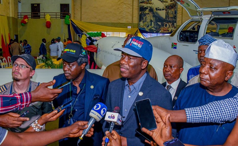
Speaking during the inspection of the Aerial Survey Aircraft (ASA) for the 2023 Mapping and Update of the Lagos State Spatial Data Infrastructure for the eGIS Project at Dominion Hangar, Murtala Mohammed Local Airport, Ikeja, the capital of Lagos on Wednesday evening, Governor Sanwo-Olu said the aerial mapping will equally help in updating the state data.
He said the exercise will also assist the Lagos State Government to plan adequately for the residents of the State.
Governor Sanwo-Olu, who was represented by his deputy, Dr. Obafemi Hamzat, said the exercise will form part of the state’s critical component of the Enterprise, Geographic Information System (EGIS) upgrade, which is aimed at providing a digital mapping platform.
The Governor said the Cessna aircraft with the registration number ZS-SSY from South Africa, would conduct the exercise for at least four and half hours daily for about six weeks, depending on the weather, while it would also fly at 4,500ft below sea level.
He said: “The aircraft has a huge camera. When it flies it can capture a coin. It flies relatively low at about 4,000ft below sea level. The essence is for it to capture everything that is in Lagos state. It can go and come back. There are layers of flying. The essence for us is to know what is in Lagos. It has a glider that can capture water and land. It would be flying for about four and a half hours daily, depending on the weather.
“We have done it before. Lagos like any other city is dynamic. What we had five years ago is not what you have today. The international standard is to do it every five years so that you can update your database and everything. So, what it does is that you can map every inch of soil in your land, and various buildings where you have your allocations and sizes.
“The essence is to know the data of your state and what that does is to enable you to plan. What you cannot measure, you cannot manage it. So, the essence for us is to be able to measure every inch of Lagos and its size.
“For us, fortunately, the census is coming up in March. If you have all those gladder information, you can map it with your census and it determines everything. It allows you to have enormous data to plan for your citizens so that you don’t globe in the dark.”
Governor Sanwo-Olu, who disclosed that the State Government had been carrying out the exercise since 2009 but chose to migrate to a bigger aircraft for more effectiveness and enhanced performance, urged Lagos residents not to panic when they see the aircraft pass through their domains in low altitude, stressing that it is for the benefit of all.
Also speaking, the Special Adviser to the Lagos State Governor on Enterprise, Geographic Information System (EGIS), and Planning Matters, Dr. Olajide Babatunde, said the project would lead to the mapping of the state’s land, noting that after the successful mapping of the State, the government would also embark on the surveying of the land.
He said the exercise was part of the projects of the enterprise geographic information system that Lagos State was building to be able to tackle some challenges bedeviling the state at the moment.
“What we are doing now is mapping and thereafter we will do a survey. This will enable us to have our spatial data infrastructure complete.
“Currently, our land use database shows that we have over 600,000 properties in the state. However, I know we have more than that. And you know if you don’t have a title deeds plan, you cannot even go to the Lagos State Parking Authority (LASPA)for building approval,” he said.
Also speaking, Lagos State Commissioner for Science and Technology, Mr. Hakeem Fahm, said the aircraft to be used for the exercise is equipped with a special camera, which showed that the State is leveraging on the power of technology to do things accurately for the benefit of Lagos citizens.
Fahm, who said he is so excited about the aerial mapping of Lagos State, said Governor Sanwo-Olu and his deputy, Dr. Obafemi Hamzat are fully committed to make Lagos greater.
The Cessna 406 aircraft operating team had been carrying out the exercise over the years in various African countries including Mozambique, Kenya, Cameroon, Burkina Faso, Niger and Rwanda.
Happy
0 %
Sad
0 %
Excited
0 %
Sleepy
0 %
Angry
0 %
Surprise
0 %